Britain will be battered by ‘exceptional’ hurricane-force winds tomorrow as ‘danger to life’ Storm Eowyn sweeps in with 90mph gusts, torrential rain and heavy snow.
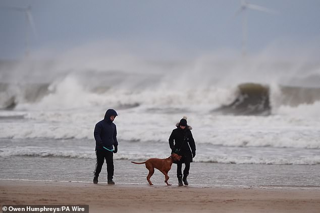
The Met Office warned the ‘high impact’ storm could even see dogs swept away by strong waves on the coast, roofs blown off houses and power lines brought down.
The UK was put on high alert from this morning with a yellow warning in place for 60mph winds along the south coast of England and up to North Wales until 6pm.
The strongest winds are then due to hit tomorrow with the entire country under yellow or amber warnings for up to 90mph gusts and up to 10in (25cm) of snow in places.
Those in northern England, southern Scotland, North Wales and Northern Ireland will face the worst conditions during an amber warning from 6am to 9pm tomorrow.
The Met Office said ‘injuries and danger to life could occur from flying debris’ and warned people to secure bins, garden furniture, trampolines, tents, sheds and fences.
It told those on the coast: ‘Stay safe during stormy weather by being aware of large waves, even from the shore large breaking waves can sweep you off your feet and out to sea. Take care if walking near cliffs; know your route and keep dogs on a lead.’
Five train operators imposed ‘do not travel’ warnings for sections of their routes tomorrow amid fears passengers could become stranded in northern England – with alerts from LNER, Avanti West Coast, Lumo, Northern and TransPennine Express.
Flights could also be impacted, with Jet2 warning of ‘some disruption should the weather deteriorate’ and Aer Lingus saying there was ‘potential disruption to travel’.
The season’s fifth named storm could be so bad that BBC weather presenter Judith Ralston said: ‘This is one major storm. I’ve not seen anything like it in my career.’
A tornado warning has been issued for southern England today – with the European Storm Forecast Experiment placing an area from Bristol to London under a level two alert for the possibility of ‘severe wind gusts with a few tornado events possible’.
The forecaster, formed of European meteorologists, said the formation of a tornado ‘cannot be ruled out’. There is also a level one alert for more of southern England and Wales, which states there is ‘similar risk but lower probabilities’ of a tornado forming.
This morning, Storm Eowyn was undergoing explosive cyclogenesis – a term more commonly known as a ‘weather bomb’ – in the Atlantic. This criteria is met when the central pressure of a low pressure system falls by more than 24 millibars in 24 hours.
The storm is then officially set to hit Britain from midnight tonight. Forecasters say travel conditions are expected to be treacherous, with coastal and exposed areas particularly at risk – but 70mph inland gusts are also expected ‘fairly widely’.
Ireland will also be hit by what will ‘probably be among the severest storms Ireland has ever seen’, shutting schools and causing major power cuts amid a red warning.


The Met Office said a major change in the UK’s weather will start today as heavy rain and strong gusts hit the country.
This will be caused by a powerful jet stream pushing low pressure across the Atlantic and towards the UK after a recent cold spell over North America.
The south coast of England, parts of the South West and much of the Welsh coast are covered by a yellow weather warning for wind from 7am until 6pm today.
Some coastal routes and sea fronts in these areas will be affected by spray or large waves, the national weather service said.
But forecasters predict the worst of the wind will happen tomorrow, when the storm arrives bringing rain and even snow over parts of Northern Ireland, Scotland and higher ground in northern England.
The whole of the UK is covered by at least one yellow weather warning tomorrow, with alerts for snow, wind and rain in place.
The strongest winds are due to hit the North of England, South of Scotland and North Wales, where an amber wind warning is in place from 6am to 9pm tomorrow – but the south of the country will also be affected.
Gusts of up to 90mph are more likely to be found along the more exposed coastal areas, while winds of between 60 to 70mph are expected inland.
The Met Office has advised people to secure loose items outside homes as there could be a danger to life caused by flying debris.
Mike Silverstone, deputy chief meteorologist at the Met Office said: ‘Storm Eowyn is expected to bring very strong winds and widespread disruption on Friday.
‘There are currently a number of weather warnings in place, with all parts of the UK covered by one warning at some point on Friday.
‘Storm Eowyn is expected to cross Northern Ireland early on Friday morning. It will then continue north-east across the northern half of Scotland during Friday afternoon and is expected to be centred near Shetland during Friday evening.’
National Highways, which operates motorways and major A roads in England, has urged motorists in the North West, North East and Yorkshire to plan for disruption tomorrow.
It has warned of ‘a particularly high risk’ that high-sided vehicles, caravans and motorbikes could be blown over.
Chris Wood, a roadside technician at the AA, said: ‘First and foremost drivers should consider if their journey is necessary or consider waiting until the storm has passed.
‘If you need to travel, choose main roads if you can, as these are less likely to be exposed to fallen branches and debris.’


Rail passengers could become stranded in the north of England as LNER has warned there will be no trains in either direction north of Newcastle from 11am tomorrow.
‘Services north of York will also be subject to short-notice cancellation and significant delay,’ an LNER spokesperson said. ‘Alternative travel options will be limited due to the nature of the weather.’
And Avanti West Coast said: ‘We’re asking customers not to travel north of Preston or between Chester and Holyhead on January 24 due to the expected disruption by Storm Éowyn.’
TransPennine Express said it was ‘urging customers not to travel’ tomorrow between Manchester/Liverpool and Scotland, and between York, Newcastle and Edinburgh.
And Lumo added: ‘On Friday 24th January due to Storm Éowyn we strongly advise that you ‘Do Not Travel’ for if you are travelling north of Newcastle in either direction.’


A yellow warning for rain has also been issued across much of Wales and South West England, where as much as 2.4in (60mm) could be seen over high ground, which may result in some flooding.
More than 10 flood alerts are in place for England today.
By Saturday, the strongest winds will have dropped for most of the country, but Storm Eowyn will continue to bring gusty weather to Scotland, with a yellow warning in place from 12am until 3pm.
The Beaufort wind force scale which is used in the UK states that speeds of more than 73mph fall in the hurricane category.
Oli Claydon, of the Met Office, said: ‘We don’t need to look that far back to see similar strength winds, with Storm Darroch just a few weeks ago.
‘And while most people don’t know the [Beaufort] scale, the gusts do fall in the hurricane speed category.
‘Certainly, winds of this strength, especially in the amber warning areas, have potential for disruptions and danger to life.’
BBC Weather presenter Simon King said the system ‘looks like being quite an exceptional storm’.
BBC Weather’s Nina Ridge added the strong winds ‘could persist well into February’ – and the Met Office has warned there is a possibility for a second named storm ‘at some point’ next week.
The Transport Scotland resilience room and the multi-agency response team will be in place to monitor conditions, while Traffic Scotland will provide updates on social media, its website and on radio broadcasts.
The Scottish Government resilience room will also be active during the period of the amber warning, and officials said they will monitor the situation and work with frontline agencies to mitigate the impact of the severe weather.
Scottish Transport Secretary Fiona Hyslop said: ‘Storm Eowyn is set to be the fourth named storm to impact Scotland this winter, bringing another period of disruption to the transport network.
‘The Met Office warnings show high winds will impact all of the country, so it’s vital people plan ahead if they have to travel, particularly in the areas in south and central Scotland covered by the amber warning.
‘The conditions will bring challenges for drivers, so you should check the Traffic Scotland website before setting off – it offers the latest information on the trunk road network and also has details of ‘wind based’ closures for the bridges. The Traffic Scotland X page is also updated regularly.
‘The high winds are likely to impact other modes of transport, so if you are planning to travel by train, ferry or air, please check with your operator to see if your service has been affected.’
Chief Superintendent Hilary Sloan, Police Scotland’s head of road policing, said: ‘The amber warning for high winds means that there is a strong likelihood of disruption on the road network and as such, motorists are advised to plan ahead and avoid unnecessary travel where possible.
‘Make sure your vehicle has sufficient fuel and is completely roadworthy, with tyre pressure and tread meeting legal requirements. Ensure your mobile phone is fully charged in the event you need to call for assistance, and if it is likely you may be within your vehicle for long periods of time, take additional clothing and water with you.
‘Please do not ignore any road signage advising of changes to speed or closures to routes. These are in place for your safety and the safety of other road users, and listen out for media broadcasts about the weather and how it may be impacting travel.
‘Further information of the weather and road closures can be found by visiting the Met Office, Ready Scotland and Traffic Scotland websites and social media accounts.’


In Ireland, Keith Leonard, chair of the National Emergency Co-ordination Group, said the storm will ‘probably be among the severest storms that Ireland has ever seen’.
He added that will result in very difficult conditions for the whole of Ireland and cause serious disruption to transport and significant power outages.
Mr Leonard also said it was likely that the number of people who will lose power in Ireland will top the 385,000 figure from Storm Ophelia in 2017.
He said those under the red warning area should shelter until the warning is lifted – but difficult conditions will remain with debris on roads and trees down.
Met Éireann has issued Status Red wind warnings for 22 counties including Dublin, Louth, Cork, Galway and Donegal from the early hours of tomorrow – with some schools set to close.
Status Red is the highest level of wind warning issued by the agency and is due to predicted ‘destructive gusts in excess of 130kph’. Met Éireann said that this brings a ‘danger to life’ as well as ‘extremely dangerous’ travelling conditions.
Status Orange wind warnings are also in place for counties in South East Ireland.
This post was originally published on this site be sure to check out more of their content.


